Chetwynd
to Tumbler Ridge / Highway 29 South
Tumbler
Ridge is located 90 km (56 miles) southeast of Tumbler Ridge. Leading
off of the highway are access roads to Sukunka Falls Provincial
Park, Gwillim Lake Provincial Park and Bullmoose Mine.
Tumbler
Ridge:
Situated on a plateau with Bullmoose and Quintette Mountains in
the backdrop, Tumbler Ridge is a good base from which to enjoy the
year-round fishing, hiking, boating, snowmobiling and cross country
skiing in the area.
 |
|
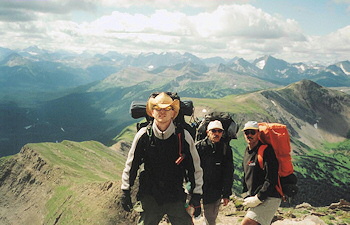
Photo
courtesy of Monkman Expeditions
|
Bullmoose
& Quintette Mine Tours: These two mines employ the majority of the
town's population. Visit the Infocentre at Southgate and Front Streets
for more information.
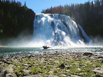
Monkman
Provincial Park and Kinusco Falls Campground:
Access is via the Murray River Forest Service gravel road, 60 km
(37 miles) from town. There is excellent wilderness camping and
hiking within the park.
 |
|
Photo
courtesy of Monkman Expeditions
|
| BC
Adventure Members serving this area: |
| Monkman
Expeditions - Join us for world-class hiking, canoeing,
and river boating adventure expeditions in the Monkman Pass
region of BC's Peace River. You'll experience the untouched
wilderness of the Rocky Mountains in Monkman Provincial Park
and area -- a place like no other. |
You
can return to Chetwynd
via Highway 29 or take alternative routes back to Highway 97.
Highway
52N (Heritage Highway) to Highway 97:
This 98km (60 miles) paved highway meets Highway 97 17km (11 miles)
west of Dawson Creek
at Arras.
Highway
52E (Boundary Road) to Dawson Creek or the Alberta Border:
This gravel road runs east then north for approximately 145 km (90
miles) from Tumbler Ridge to Highway 2 at Tupper, on the BC/Alberta
border.
Chetwynd
to Fort St. John/Highway 29 North
From
Chetwynd to Fort
St. John, Highway 29N passes by the small community of Moberly
Lake, onto Hudson's Hope, the WAC Bennett Dam and the Peace Canyon
Dam. Before arriving at Hudson's Hope you will cross over the Peace
River on it's only suspension bridge.
Peace
Canyon Dam and Generating Station:
This is the second largest hydroelectric project (the WAC Bennett
Dam is the first) on the Peace River. It is located on the east
side of Highway 29 before Hudson's Hope.
Hudson's
Hope:
Situated above the Peace River, Hudson's Hope is located on Highway
29, 64 km (40 miles) north of Chetwynd. It was first established
in 1805 as the Rocky Mountain Portage by Simon Fraser.
Hudson's
Hope Museum:
With displays of gold mining equipment and early trapping and pioneer
artifacts, this museum is located at 105th Avenue.
Side
Trip to Bennett Dam:
Access to the Bennett Dam is via the Dam Access Road off of Highway
29. The viewpoint is located 22 km (14 miles) from the highway and
offers excellent views of the dam and the mountains and surrounding
area. It is located on Williston Lake and is BC's largest reservoir.
Visitors
Centre of the WAC Bennett Dam and Gordon Shrum Generating Station:
Offering free guided tours of the powerhouse.
Peace
Canyon Visitor Centre:
The visitor centre provides information about the areas natural
history and includes a life-size dinosaur replica and casts of footprints
which were found during the construction of the dam.
Continuing
along Highway 29N is the Halfway River located halfway between Fort
St. John and Portage Mountain with good grayling, whitefish, Dolly
Varden and rainbow trout fishing. The junction of Highways 97 and
29 is located just past Bear Hill, 13 km (8 miles) north of Fort
St. John.